Laser-enabled aerial LiDAR for Delhi-Varanasi hi-speed corridor
Technology

Laser-enabled aerial LiDAR for Delhi-Varanasi hi-speed corridor


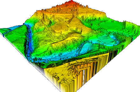
National High Speed Rail Corporation Limited (NHSRCL) will be adopting Light Detection and Ranging Survey (LiDAR) technique using laser enabled equipment mounted on a helicopter for conducting ground survey for the preparation of Detailed Project Report (DPR) for the proposed Delhi-Varanasi HSR corridor (DVHSR).

Keeping in mind the magnitude of the project and adhering to the timelines to submit the DPR of DVHSR corridor, the ground survey using aerial LiDAR technique has already started. Reference points on the ground have already been marked and data collection through equipment mounted on a helicopter will commence from December 13 (depending on the weather conditions) in a phased manner. The requisite permissions from the Ministry of Defence for flying the helicopter have been received and the inspection of the aircraft and equipment are underway.

The aerial LiDAR survey technique is expected to save time exponentially. The first instance of the aerial technique for a railway project in India was adopted for the Mumbai- Ahmedabad High Speed Rail Corridor, chosen primarily because of its high accuracy. The ground survey using aerial LiDAR for MAHSR alignment was done only in 12 weeks against the 10-12 months if had been done through traditional survey methods.

The proposed Delhi-Varanasi HSR alignment covers mixed terrains including densely populated urban and rural areas, highways, roads, ghats, rivers, green fields etc. which makes this activity more challenging. The tentative length of the corridor is about 800 km. The alignment and stations will be decided in consultation with the government.

The alignment or ground survey is a crucial activity for any linear infrastructure project as the survey provides accurate details of areas around the alignment. This technique uses a combination of laser data, GPS data, flight parameters and actual photographs to give accurate survey data. Based on the findings of the survey, designing of the vertical and horizontal alignment, structures, location of the stations and depots, land requirement for the corridor, identification of project affected plots or structures, right-of-way, and so on, are decided.

NHSRCL has been entrusted by the Ministry of Railways with preparing the Detailed Project Report (DPR) for the Delhi-Varanasi high-speed corridor.

Source: Press Information Bureau (Government of India)

Also read: Bids invited for Delhi-Amritsar high-speed rail corridor

Image credit: Base Camp Aviation

National High Speed Rail Corporation Limited (NHSRCL) will be adopting Light Detection and Ranging Survey (LiDAR) technique using laser enabled equipment mounted on a helicopter for conducting ground survey for the preparation of Detailed Project Report (DPR) for the proposed Delhi-Varanasi HSR corridor (DVHSR). Keeping in mind the magnitude of the project and adhering to the timelines to submit the DPR of DVHSR corridor, the ground survey using aerial LiDAR technique has already started. Reference points on the ground have already been marked and data collection through equipment mounted on a helicopter will commence from December 13 (depending on the weather conditions) in a phased manner. The requisite permissions from the Ministry of Defence for flying the helicopter have been received and the inspection of the aircraft and equipment are underway. The aerial LiDAR survey technique is expected to save time exponentially. The first instance of the aerial technique for a railway project in India was adopted for the Mumbai- Ahmedabad High Speed Rail Corridor, chosen primarily because of its high accuracy. The ground survey using aerial LiDAR for MAHSR alignment was done only in 12 weeks against the 10-12 months if had been done through traditional survey methods. The proposed Delhi-Varanasi HSR alignment covers mixed terrains including densely populated urban and rural areas, highways, roads, ghats, rivers, green fields etc. which makes this activity more challenging. The tentative length of the corridor is about 800 km. The alignment and stations will be decided in consultation with the government. The alignment or ground survey is a crucial activity for any linear infrastructure project as the survey provides accurate details of areas around the alignment. This technique uses a combination of laser data, GPS data, flight parameters and actual photographs to give accurate survey data. Based on the findings of the survey, designing of the vertical and horizontal alignment, structures, location of the stations and depots, land requirement for the corridor, identification of project affected plots or structures, right-of-way, and so on, are decided. NHSRCL has been entrusted by the Ministry of Railways with preparing the Detailed Project Report (DPR) for the Delhi-Varanasi high-speed corridor. Source: Press Information Bureau (Government of India) Also read: Bids invited for Delhi-Amritsar high-speed rail corridor Image credit: Base Camp Aviation

Next Story
Products

Viva ACP Launches FR A1-Rated Honeycomb Panels for Fire Safety

Viva, Asia’s largest manufacturer and supplier of aluminium composite panels (ACP) introduced its FR A1-rated Honeycomb Panels, setting a new industry benchmark for fire safety and architectural excellence. Engineered to deliver exceptional performance, these panels combine advanced fire-resistance technology with aesthetic versatility, offering a revolutionary solution for safety-critical environments.The FR A1 rating represents the highest standard of fire resistance under the European Standard EN 13501-1, signifying non-combustibility and zero contribution to fire, smoke, or toxic emissio..

Next Story
Real Estate

Almal Real Estate Expands into Commercial, Global Markets

Almal Real Estate Development is soon to announce its upcoming expansion into new verticals and international markets as part of its strategic growth plans for 2030. The company, known for its innovative luxury residential and hospitality developments, is preparing to diversify into the commercial sector with the introduction of The Smart Space, a network of business centers in UAE featuring five-star amenities. Additionally, Almal is entering new markets in Bali and Thailand as a community developer, focusing on villa and townhouse projects.The expansion into the commercial real estate sector..

Next Story
Infrastructure Urban

NABARD Approves Rs 9.03 Billion for 127 Projects in Himachal

The Himachal Pradesh government has secured approval from the National Bank for Agriculture and Rural Development (NABARD) for 127 projects worth Rs 9.03 billion for the 2024-25 fiscal, Chief Minister Sukhvinder Singh Sukhu announced. During a meeting with MLAs from Kangra, Kullu, Kinnaur, Solan, Chamba, Bilaspur, and Lahaul-Spiti districts to discuss priorities for the 2025-26 budget, Sukhu said the approved projects include 50 MLA-priority schemes under the Public Works Department, valued at Rs 4.12 billion, and 23 MLA-priority schemes under the Jal Shakti Vibhag, costing Rs 1.79 billio..

Advertisement

Advertisement

Subscribe to Our Newsletter

Get daily newsletters around different themes from Construction world.

STAY CONNECTED

Advertisement

Advertisement

Advertisement

Advertisement

Talk to us?