Lucknow to monitor illegal construction via digital mapping
Real Estate

Lucknow to monitor illegal construction via digital mapping

Lucknow Development Authority (LDA) will begin digital mapping of the city with the help of the Remote Sensing Application Centre in order to keep an eye on unauthorised construction and infrastructure monitoring within the city limits.

The scientists from the Remote Sensing Application Centre met with LDA officials and presented them with a report on their satellite survey and mapping activities in the Ghaziabad district.

Following the meeting, LDA Vice-Chairman Akshay Tripathi directed them to improve the technical stability and profitability of the system.

According to him, digital mapping of the city is necessary to prevent illegal construction. A proposal for the entire action plan has been requested from the remote sensing department.

The LDA has jurisdiction over an area of about 1,050 square km. Every month, they plan to create a database of satellite images of the entire area so that any unauthorised construction in the city can be tracked, said Tripathi.

The plot area, constructed area, and land use must all be known, so the mapping must be done in six to seven layers using the satellite view, drone survey, and Google map.

He went on to say that the system should be designed so that mobile locations of any illegal construction can be found at the latitude-longitude level. All of this information can be linked to the portal in the future.

Image Source


Also read: Permissions no longer needed for geospatial surveys, mapping

Lucknow Development Authority (LDA) will begin digital mapping of the city with the help of the Remote Sensing Application Centre in order to keep an eye on unauthorised construction and infrastructure monitoring within the city limits. The scientists from the Remote Sensing Application Centre met with LDA officials and presented them with a report on their satellite survey and mapping activities in the Ghaziabad district. Following the meeting, LDA Vice-Chairman Akshay Tripathi directed them to improve the technical stability and profitability of the system. According to him, digital mapping of the city is necessary to prevent illegal construction. A proposal for the entire action plan has been requested from the remote sensing department. The LDA has jurisdiction over an area of about 1,050 square km. Every month, they plan to create a database of satellite images of the entire area so that any unauthorised construction in the city can be tracked, said Tripathi. The plot area, constructed area, and land use must all be known, so the mapping must be done in six to seven layers using the satellite view, drone survey, and Google map. He went on to say that the system should be designed so that mobile locations of any illegal construction can be found at the latitude-longitude level. All of this information can be linked to the portal in the future. Image Source Also read: Permissions no longer needed for geospatial surveys, mapping

Next Story
Infrastructure Energy

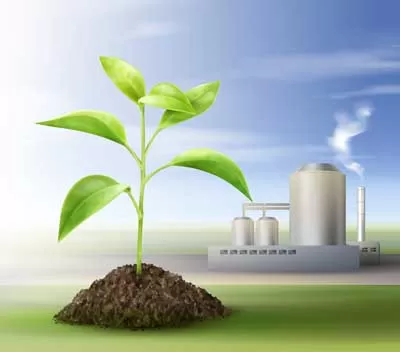
Samridh, CEID Launch High-Capacity Biogas Plant in Moradabad

Samridh Bioenergy has broken ground on a 12 TPD compressed biogas (CBG) plant in Moradabad, Uttar Pradesh, under the MNRE’s National Bioenergy Programme. Spread across 12 acres, the plant will process 270 tonne of organic waste daily and generate 30,000 cubic metre of biogas per day.CEID Consultants and Engineering Pvt Ltd has been appointed as the EPC contractor, responsible for the complete design, procurement, and construction of the plant. Equipped with four multi-feed digesters, the facility will accept a mix of press mud, cow dung, chicken litter, and vegetable waste, supporting contin..

Next Story
Real Estate

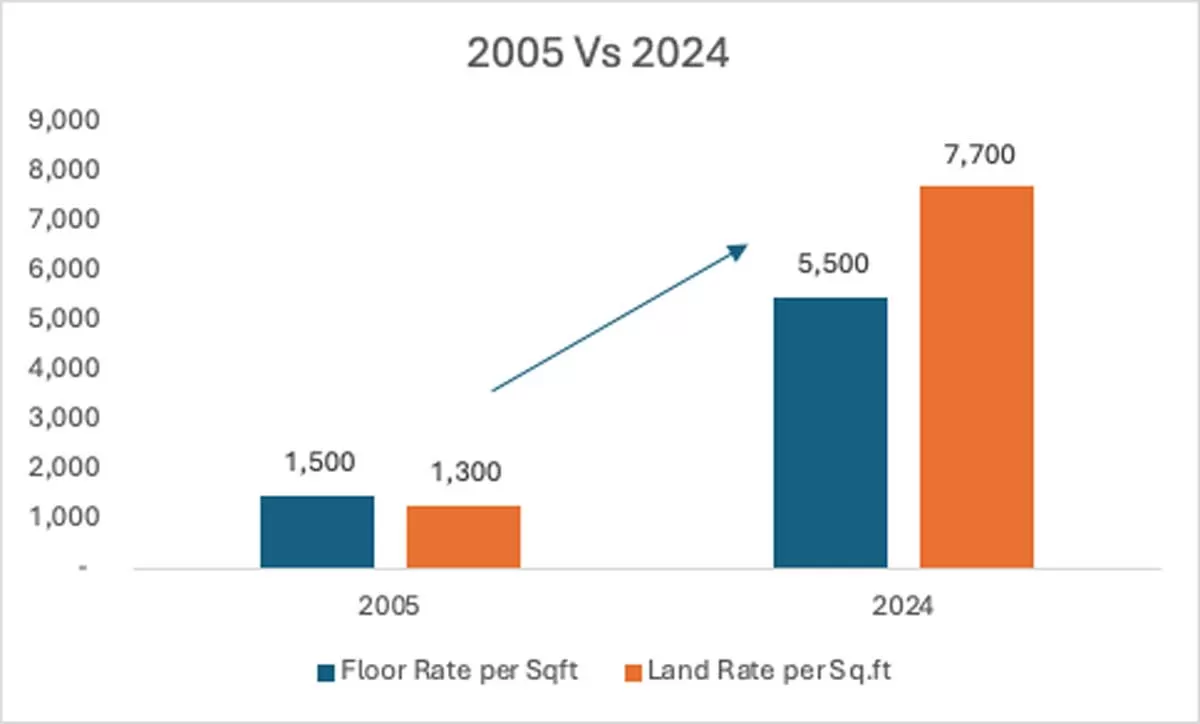
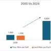
Delhi Micro-Markets Drive Up Housing Prices: Grihum Study

A new study by Grihum Housing Finance reveals that the rise of micro-markets across Delhi-NCR is fuelling real estate price appreciation, especially in the affordable housing segment. Key drivers include renewed post-pandemic interest, migration trends, and government schemes like PMAY.According to the study, over the past two decades, floor rates have risen 267 per cent, from Rs 1,500 per sq ft in 2005 to Rs 5,500 in 2024. In the same period, land rates surged 492 per cent, from Rs 1,300 to Rs 7,700 per sq ft. The sharp increase highlights strong capital appreciation in Delhi’s emerging loc..

Next Story
Resources

Covestro Develops PCR Polycarbonates from End-of-Life Headlamps

Materials manufacturer Covestro has launched post-consumer recycled (PCR) polycarbonates made from end-of-life automotive headlamps, in a move aimed at strengthening circularity in the auto industry. These TÜV Rheinland-certified grades, containing 50 per cent recycled content, are now commercially available for new automotive applications.Developed under a joint programme led by GIZ, with Volkswagen and NIO as key partners, the recycled material is currently being validated for use in future vehicle models.""This new line of polycarbonate represents a significant step in supporting the autom..

Advertisement

Advertisement

Subscribe to Our Newsletter

Get daily newsletters around different themes from Construction world.

STAY CONNECTED

Advertisement

Advertisement

Advertisement

Advertisement

Talk to us?